
Oceanic whitetip shark
Enormous rounded white-tipped fins, a slow blue-water cruise — and the steepest collapse of any shark in this library.
Vital statistics
Live birth with a true placenta after 10–12 months; 1–15 pups (average about 6) at 60–65 cm, usually only every second year.
The short version
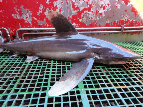
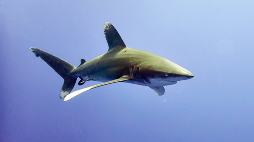
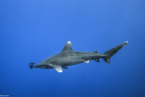
The oceanic whitetip is a big, thickset shark of the warm open sea, and its fins give it away instantly: the first dorsal is tall and rounded like a paddle instead of pointed, the pectorals are extraordinarily long — longimanus means “long hands” — and both are mottled white at the tip. It lives between about 30° N and 35° S in every ocean, out over water kilometres deep, cruising slowly near the surface with pilot fish in attendance. The biggest one ever measured was 3.5 m; the heaviest weighed 167.4 kg.
It is also the steepest decline in this library. Two biologists writing in 1969 called it “perhaps the most abundant large animal, large being over 100 lbs, on the face of the earth”; in 2019 it was assessed as Critically Endangered on an inferred global reduction of more than 80% over three generations. Regional estimates run from 88% in the Gulf of Mexico to 95% in the western and central Pacific, and NOAA puts the range-wide loss since the 1990s at at least 75%. The exact figures are argued over, because nobody ever counted these sharks; the direction is not. The cause is bycatch on tuna and swordfish longlines, plus fins worth keeping.
Its reputation is a historical artefact. Jacques Cousteau called it “the most dangerous of all sharks”, but the stories behind that line come almost entirely from torpedoed ships and downed aircraft in the open ocean, not from anything a swimmer would encounter: the global incident file, which starts in 1580, lists 15 unprovoked cases. Today it runs the other way: this shark is now so scarce that seeing one is a privilege, and only a handful of places — above all Cat Island in The Bahamas each spring — deliver one reliably.
Where it lives
The oceanic whitetip lives in the warm open sea, and the word oceanic is doing real work. It is found between about 30° N and 35° S in every ocean — Maine to Argentina, Madeira to the Gulf of Guinea, the Red Sea, Hawai‘i to Tahiti, southern California to Peru — which puts it in the waters of more than fifty countries. Within that band it is an animal of the deep tropics: numbers peak between 10° N and 10° S and thin out towards land. It wants water deeper than about 184 m beneath it, so it comes near a coast only where the coast itself drops away fast — oceanic islands, the outer shelf edge, the steep offshore reefs of the Egyptian Red Sea.
Temperature draws the boundary. FishBase and the Florida Museum both give 18–28 °C; NOAA’s status review widens that to 15–28 °C but stresses the real preference, which is the sunlit surface layer above 20 °C. Sharks tagged in the central Pacific stayed within 2 °C of the sea surface more than 95% of the time. The cold water around the southern tips of Africa and South America may work as a wall: Atlantic and Indo-Pacific whitetips are genetically distinguishable.
They do leave the warm layer, briefly. Every one of eleven sharks tagged off the Bahamas made short dives below the thermocline, averaging thirteen minutes, the deepest to 1,082 m and 7.75 °C — a record that pushed the species’ known depth range down by hundreds of metres in 2013. Those dives come mostly at night and look like hunting trips after deep squid. The other 99.7% of the time this is a shark of the top 200 m of blue water, which is why almost nobody meets one, and why it is a rare face on our map.


- Cat Island, The Bahamas — The one dependable aggregation left in the Atlantic, and the reason most of what we know about the species comes from one small patch of sea. Adults gather here in spring; eleven mature sharks were satellite-tagged over eight days in May 2011, and mating behaviour and raised male hormone levels have been logged from April to July.
- The Egyptian Red Sea — Elphinstone, the Brothers and Daedalus are offshore pinnacles with deep water on every side, and NOAA’s status review names the Red Sea as one of only four places in the world where dive operators can take people to see this shark. Egypt has banned shark fishing out to 12 miles from its Red Sea coast since 2005.
- Kona, Hawai‘i — Deep water within sight of the island, and one of the places where oceanic whitetips are met alongside short-finned pilot whales. A shark filmed here carried sucker scars from a large squid — evidence that the night dives are hunting trips.
- The equatorial Atlantic off Brazil — Longline catches here are overwhelmingly juveniles — in one study 80.7% of males and 89.4% of females were immature — which suggests nursery water, though no oceanic whitetip nursery has ever been properly located.
- The western and central Pacific — Still the species’ heartland, and the site of its worst collapse. The only formal stock assessment anywhere found this stock overfished, with declines of up to 95% since 1995.
Where it goes
The best picture we have comes from eleven mature sharks tagged off Cat Island in May 2011. They held within 500 km of the tagging site for about a month, then scattered across 16,422 km² of the western North Atlantic, ending 290 to 1,940 km from where they started after tracks of 1,810 to 7,941 km. Then came the surprise: many turned round and were back in The Bahamas after about 150 days, one was photographed at Cat Island again nearly a year later, and a shark from NOAA’s tagging programme was caught in the same waters three years after it was tagged. A shark that wanders an ocean and still comes home was not what anyone expected of an open-ocean species. Eight sharks tagged off Brazil did the same: five finished close to where they began. The Pacific record for a straight-line movement is 4,285 km in 95 days.
Everything after that is honestly thin. NOAA’s Cooperative Shark Tagging Program tagged 645 oceanic whitetips between 1962 and 2015 and got just eight back — half a century of Atlantic tagging, eight data points. Nobody has found the nursery grounds; they are assumed to be out in open water. Birth seems to happen in late spring and summer in the northwest Atlantic, but females in the North Pacific carry embryos in almost every month. Even the reason for the Cat Island gathering is unsettled: isotope work points at food, including big fish hooked by sport fishermen, the hormone work at mating. It may be both.
Share of verified oceanic whitetip shark records by month (GBIF, all years). Darker rose means a larger share of sightings fall in that month. This reflects when people record them, which mixes real seasonality with when divers and boats are out.
Cat Island, The Bahamas: The Cat Island aggregation, not the species. Mating behaviour and raised male hormone levels were recorded there from April to July, and tagged sharks held station nearby through May before dispersing — which matches what local dive operators had been saying for years. A zero month does not mean the sharks are gone from the ocean; it means they are spread thinly across the western North Atlantic where nobody sees them.
What it eats
Bony fish and squid, plus whatever else turns up. Stomach contents from the 1950s held blackfin tuna, barracuda and white marlin; the wider list adds rays, smaller sharks, seabirds, turtles, scavenged whale carcasses and, depressingly often, rubbish. Isotope work at Cat Island shows the menu shifting with the address: large pelagic fish made up 72% of the aggregation’s recent diet against 47% over the longer term — the difference being tuna, marlin and dolphinfish, some of them hooked by sport fishermen. A shark of the open sea cannot afford to be fussy; meals arrive at no set interval.
The hunting style is patience rather than speed. Four sharks carrying speed-logging tags cruised at 0.6–0.7 m/s — about 2.5 km/h, slower than walking pace — on a budget of barely a kilogram of food a day. That thrifty cruise is punctuated by bursts of up to 4.6 m/s, including charges begun 160 m down that end with the shark breaching the surface. It also explains the old reputation as a follower: whitetips trailed whaling ships for floating carcasses, gathered twenty-five at a time at 1950s longlines to strip tuna off the hooks, and are reported to travel with short-finned pilot whales, which dive for the same deep squid. Following something that has already found food is cheaper than searching an empty ocean.
Is it dangerous?
This shark has the fiercest reputation in the library and one of the shortest incident records. Jacques and Philippe Cousteau called it “the most dangerous of all sharks” in 1970, and the verdict stuck — but look at where it came from. The accounts behind it are wartime sinkings and ditched aircraft: people in the water for days, hundreds of miles offshore, in exactly the habitat where this is the shark that turns up and stays. That is not a description of swimming at a beach. The International Shark Attack File, whose record starts in 1580, holds 15 unprovoked oceanic whitetip incidents against 351 for the white shark, and surfers and swimmers are essentially never in the same water. The people who do meet them are divers on organised trips, where the rules are the operators’ own: no bait in your hands, no speared fish on your belt, and let the shark come and go on its own terms.
Turn the comparison round and it is not close. Oceanic whitetips are caught in enormous numbers as bycatch on the longlines and purse seines set for tuna and swordfish, and their large, high-value fins give crews a reason to keep them. Weighing bycatch data since the 1990s, NOAA puts the decline at at least 75% across the species’ range. Every measure since has been aimed at the boats rather than the sharks — retention bans by all four tuna commissions between 2011 and 2013, CITES Appendix II in 2014, a US threatened listing in 2018, a US Atlantic retention ban in 2024. There are early signs it is working — the northwest Atlantic looks stable or slightly up since 2010, and mortality in pelagic fisheries is falling — but illegal fishing and the fin trade carry on, and a shark that matures at six to nine years old and has about six pups every other year rebuilds slowly.
Oceanic whitetip shark facts
- In 1969 Thomas Lineaweaver and Richard Backus described the oceanic whitetip as “extraordinarily abundant, perhaps the most abundant large animal, large being over 100 lbs, on the face of the earth”. It was a description, not a census — but it is what a working marine biologist thought fifty-odd years ago about a shark now listed as Critically Endangered. — Lineaweaver & Backus, The Natural History of Sharks (1969)
- The most-quoted collapse figure — a fall of more than 99% in the Gulf of Mexico between 1950s research longlines and 1990s observer data — is disputed. Critics pointed out that modern sets are deeper and no longer use wire leaders, both of which reduce how many sharks a hook catches; re-working the same data for those differences gives 88%. Either way it is a collapse. — NOAA Fisheries Recovery Status Review 2024 (Baum & Myers 2004; Burgess et al. 2005; FAO 2012)
- The only formal stock assessment ever done for this species, covering the western and central Pacific, found the stock both overfished and still being overfished, with declines of up to 95% since 1995 — and most of the historical decline had already happened before 1995. — Tremblay-Boyer et al. 2019, via NOAA Fisheries Recovery Plan 2024
- Every one of eleven sharks tagged off Cat Island made short dives below the thermocline, averaging 13 minutes and mostly at night, the deepest reaching 1,082 m and 7.75 °C. The other 99.7% of their time was spent shallower than 200 m. — Howey-Jordan et al. 2013, PLOS ONE
- Four oceanic whitetips fitted with speed loggers cruised at just 0.6–0.7 m/s — about 2.5 km/h — with bursts to 4.6 m/s, and the study calculated that an adult’s daily energy needs are covered by around 1–1.5 kg of food, roughly 1.5% of its body weight. — Papastamatiou et al. 2018, Scientific Reports
- NOAA’s Cooperative Shark Tagging Program tagged 645 oceanic whitetips between 1962 and 2015 and recovered only eight: the longest at liberty 3.3 years, the furthest 2,270 km. Half a century of Atlantic tagging has produced a handful of data points. — Kohler & Turner 2018 / NOAA Fisheries
- The International Shark Attack File, which runs from 1580 to the present, records 15 unprovoked oceanic whitetip incidents — 12 non-fatal and 3 fatal — compared with 351 for the white shark and 142 for the tiger shark. — Florida Museum, International Shark Attack File
- Every tuna commission on earth now bans keeping one: ICCAT in the Atlantic from 2011, and the Indian Ocean, eastern Pacific and western and central Pacific commissions from 2013. The species joined CITES Appendix II in 2014, was listed as Threatened under the US Endangered Species Act in 2018, and retention became illegal in US Atlantic waters in February 2024. — ICCAT Recommendation 10-07; NOAA Fisheries; 89 FR 273
Photos
Seen lately
PierMonkey’s live map carries community shark sightings from iNaturalist, refreshed every three hours. Open the map to see where oceanic whitetip sharks have turned up recently.
How big is that, really?
Maximum reliably recorded length. Rose marks the large or potentially dangerous species the map flags as notable.
Help protect it
- NOAA Fisheries — oceanic whitetip safe release guideIf you fish or crew offshore, this is the one-page protocol for getting a hooked whitetip off the line alive: the species must not be targeted and must be released so it survives. Post-release survival is the single number the recovery plan is betting on.
- NOAA Fisheries — oceanic whitetip identification guideLearn the paddle-shaped dorsal and the long white-tipped pectorals so you can separate this shark from a silky or a dusky at the side of a boat. Misidentification is why so many catch records are useless; a correctly named release is data.
- The Shark Trust — Oceanic ProgrammeThe whole problem for this species sits on the high seas, where no single country is in charge. Back the campaign that works on the tuna commissions — they wrote the retention bans, and they are the only bodies that can make them bite.
Report what you see
Photograph a shark, upload it, and once the community confirms the ID it becomes a research-grade record — which is where every sighting on our map comes from. Yours would appear here within three hours.
How to submit an observation →Organisations working on sharks like this one
- The Shark Trustgood for kidsReport eggcases and sightings, join campaigns, download free ID guides.
- Great Eggcase Huntgood for kidsWalk a beach, find a mermaid’s purse, log it. Over 630,000 eggcases recorded since 2003 — the easiest real science a family can do.
- Sharks4Kidsgood for kidsFree classroom lessons, virtual field trips and activity packs for teachers and parents.
- Save Our Seas FoundationFunds shark research and education worldwide; publishes what each project found.
- Shark StewardsCampaigns to end the shark fin trade and establish shark sanctuaries.
- OceanaPolicy campaigning on fisheries management and bycatch — the thing that actually kills sharks.
- IUCN Shark Specialist GroupThe scientists behind the Red List assessments. For older readers who want the primary source.
Conservation status: Critically Endangered (IUCN Red List, assessed 2019). Assessed Critically Endangered in 2019 on an inferred global population reduction of more than 80% over three generations, which that assessment takes as 61.2 years; NOAA’s 2024 rulemaking quotes the same assessment’s median model estimate at 98–100% and calls it the only global trend figure available. Nobody has ever counted oceanic whitetips, so every number here is reconstructed from fishing records. The United States lists the species as Threatened rather than Endangered under its own Endangered Species Act — a different test, applied in 2018 and upheld by the 2025 five-year review, which found the decline real but the recent trend in some regions flat or rising. Read the assessment →
Common questions
Why is the oceanic whitetip Critically Endangered when it used to be so common?▾
Was Cousteau right that it is the most dangerous of all sharks?▾
How do you recognise an oceanic whitetip shark?▾
Where can you still see an oceanic whitetip?▾
Why do oceanic whitetips follow ships and pilot whales?▾
Why does the United States call it Threatened when the IUCN calls it Critically Endangered?▾
Keep exploring
Sightings © iNaturalist contributors (research-grade observations). Occurrence maps © GBIF.org contributors (CC BY). Community science, not a beach-safety service. Last updated 2026-09-20.
See where sharks are turning up — on the live map
The map and live conditions are open to everyone. A free account unlocks full 16-day forecasts and custom swell alerts.